


It would save everyone a lot of time to have a definitive answer to the question, “Which is better, aerial or satellite imagery?” But as with many technology-related issues, the answer is, “It depends.” To narrow down the options, ask yourself:
- What features and information need to be visible in or extracted from the imagery?
- What accuracy is required?
- How often will the imagery be updated?
- What price point fits the budget?
The answers to these questions will help guide your purchasing decision toward the right imagery for your project.
Spatial resolution and spectral quality
Spatial resolution impacts the level of detail, or size of a feature, distinguishable in the image, while the spectral bands (e.g., panchromatic, colour [R,G,B], near-infrared [NIR], shortwave-infrared [SWIR]) determine the type of analysis that can be performed with the imagery. For example, a very high-resolution orthorectified colour image is preferable for urban planning, while a lower resolution false colour (NIR) image is appropriate for agriculture.
Customer expectations for spatial resolution have escalated along with the improved capabilities of remote sensing satellites and aerial cameras. In the “good old days” 30-metre remotely sensed data was the best satellite imagery available to the public. Now you can browse 30-centimetre imagery online and download many areas of the globe without leaving your desk.
Digital aerial cameras have been refined to the point where 5-cm resolution in urban areas is a normal requirement, with the added benefit of acquiring cloud-free data. Airborne imagery provides the absolute best image resolution possible, while satellite imaging is more practical for areas that are difficult to access or dangerous.
Specific spectral bands in the electromagnetic spectrum support different types of analysis. There is a wide range of capabilities in aerial cameras and satellites—from panchromatic to hyperspectral. Aerial cameras typically collect panchromatic and multispectral (R,G,B,NIR) imagery, while some satellites are able to collect hundreds of bands, although at a much lower resolution. Knowing the intended use of the imagery before purchasing is crucial to ensure access to the necessary information.
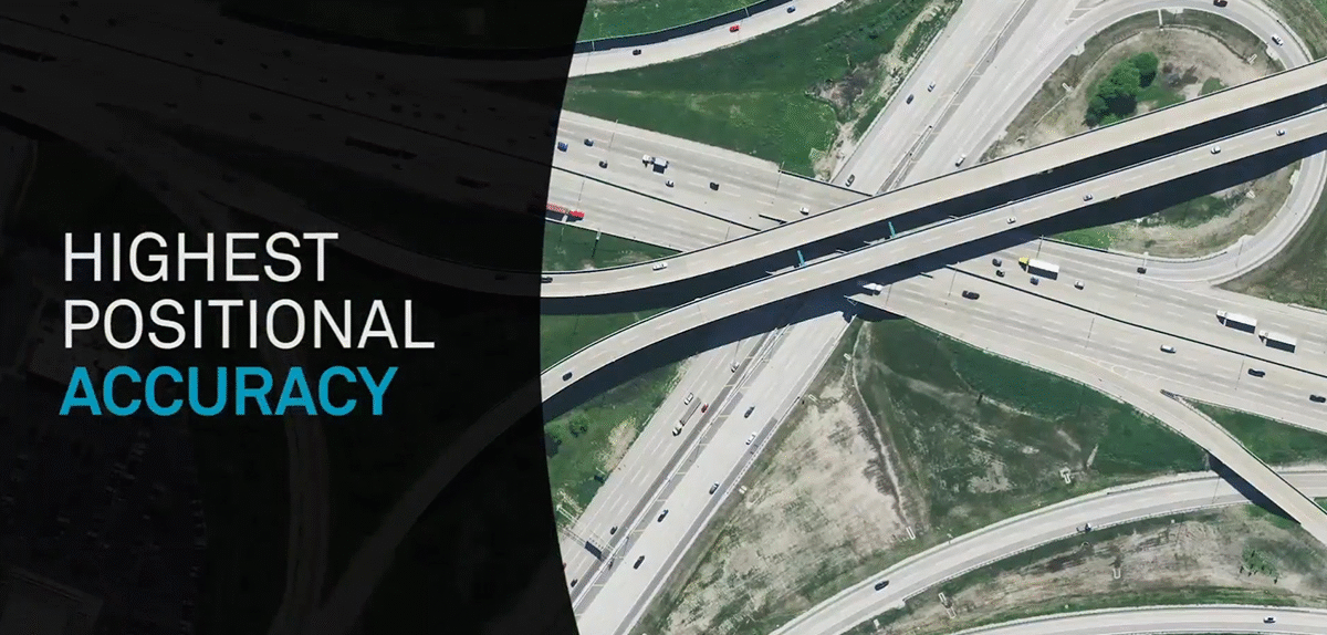
Positional accuracy
Another important factor in selecting an imagery provider is positional accuracy. Expressed as RMSE (root-mean square error), horizontal accuracy is crucial for matching your data with existing projections. Without a high degree of positional accuracy, aerial and satellite imagery would be less useful for mapping because time-consuming work on the ground would still be required. To put this into perspective, the HxGN Content Program delivers 15-cm resolution imagery with <1 m RMSE, as compared to the highest resolution satellite imagery which guarantees 30-cm resolution and accuracy of 3-5 m CE 90 or better.
To acquire mapping-grade imagery, aerial cameras always shoot close to nadir (looking straight down) which is what gives better visibility to map all features in urban environments. To capture tall buildings, supplemental aerial flight lines are added to provide more overlap in critical, dense urban areas. Flexibility is an advantage of aerial imagery, meaning aircraft can be deployed when conditions are ideal, providing data sets of high image quality that are not affected by atmospheric or terrain conditions, and pilots can adapt flight paths if necessary.
In contrast, satellites collect imagery on a set schedule, rain or shine, revisiting the same area at the same time every few days. The lower accuracy of satellite images is adequate for a number of applications, while the higher accuracy of aerial imagery provides better maps for urban planning with fewer ground control points.
Temporal resolution
When frequent revisits are required, such as in a surveillance situation, satellite imagery has the advantage of automated collection that ensures the satellite is passing over the same area every few days, without additional labour hours as compared to traditional aerial mapping projects that include mobilisation costs, weather delays, pilots and camera crews.
To obtain coverage of an area that requires multiple flight lines, aircraft offer more flexibility. They can fly at different times of day when the weather is optimal and can often fly below the clouds. To get consistent imagery over a metro area, aircraft can complete collection within a tight time frame so that seasonality is consistent throughout the map.
3D models are created using overlapping imagery. Satellites need multiple collection days to provide overlapping imagery, so it may take months or even years to get full coverage. Depending on the size of the area of interest, aerial coverage can be acquired within a few days, which results in a more consistent deliverable.
 Some of the main benefits that aerial data provides
Data consistency enables AI & machine learning applications
AI and machine learning algorithms used for automatic feature extraction and advanced analytics from geospatial data depend on large, consistent imagery to be successful. Therefore, it makes sense to use aerial imagery for AI applications because it achieves the highest data consistency by focusing on repeatability in sensor technology, flight planning, acquisition parameters and processing techniques. While satellite data includes atmospheric artefacts and seasonal discrepancies, aerial imagery is cloud-free and captured during optimal weather and atmospheric conditions. The data sets are normalised to offer consistent input so that engines can focus on detecting the correct objects.
The right data for your project
There is always a trade-off between resolution and cost. The higher the resolution, the more detail you receive and the higher the price. Keeping your budget in mind, it makes sense to purchase the resolution and accuracy required for your project. Although there might be higher resolution available, you might want to add additional criteria to your decision-making process, such as data quality, positional accuracy and continuity of data supply.
Government agencies are finding it helpful to form consortiums to share the cost of high-quality data sets that they couldn’t afford individually. This is where Content-as-a-Service (Caas) programs come into play. Instead of paying for custom acquisition, data buyers can turn to CaaS programs that continuously capture data according to pre-defined specifications and refresh schedules to create a standardised product suitable for many applications. Many customers are collectively underwriting the collection cost and can, therefore, pay a significantly reduced price.
The HxGN Content Program is the largest high-quality aerial image library with 30 cm resolution coverage across the United States and most of Europe and 15 cm resolution in metro areas of the United States (see coverage map). The program also offers digital surface models and stereo imagery across all coverage areas and is specifically designed for applications that require high quality, consistent data across wide areas.
Contact our team for more information.