


Only weeks after Hurricane Irma sideswiped the island, the Commonwealth of Puerto Rico suffered a direct hit from Hurricane Maria on September 20, 2017. The devastation was historic: over 3,000 lives lost, total power grid failure, thousands of landslides, and numerous roads either blocked or washed away.
As humanitarian response evolved into rebuilding, it became obvious that long-term recovery depended on repairing the transportation network, and accurate, high-resolution imagery would be key. Puerto Rico obtained orthorectified aerial imagery from Hexagon’s HxGN Content Program covering the entire land area before the storms struck. The four-band, 6-inch resolution (15-centimeter) imagery had been captured in the months prior, making the data set the most up-to-date pre-event information available.
Throughout these efforts, PRX Solutions, a GIS consultancy and Hexagon’s reseller in Puerto Rico, worked closely with private and public sector organizations to ensure the streaming of aerial imagery was readily accessible.
“In the days, weeks and even years after Maria, the pre-hurricane imagery took center stage, offering an invaluable resource for comprehensive understanding,” said Joel Melendez, Senior Consultant at PRX Solutions. “The imagery facilitated a measured response grounded in facts that enabled decision makers to evaluate the extent of damage, gauge potential access routes, and determine the scope of infrastructure damage.”
The pre-disaster imagery proved invaluable in every step of the hurricane response and recovery. It served as the baseline data set for comparison with the post-storm imagery, enabling emergency managers to identify high population zones and prioritize deployment of resources. The pre-event images also helped searchers find access routes to reach victims and evacuate them to safety. In many cases, responders relied on the images to flag and avoid potential hazards, such as landslide areas, that could put their lives at risk during rescue efforts.
Focusing on infrastructure repair using pre-disaster aerial imagery
“It was the first time so many bridges had fallen down,” said Miguel Martinez, a GIS Specialist with the Puerto Rico Department of Transportation at the time. “The water took everything away and we needed imagery to know the details of what had been there.”
Visual details meant everything to Martinez, who was assigned to damage assessment in the Emergency Operations Center. His team was tasked with comparing Hexagon’s pre-event imagery with new geospatial data acquired days after Maria by the U.S. government. The team inventoried each lost bridge using the baseline imagery to determine the support structure, number of spans, overall width and length, and configurations of approach lanes. Other teams were performing similar assessments of the road network and electric grid.
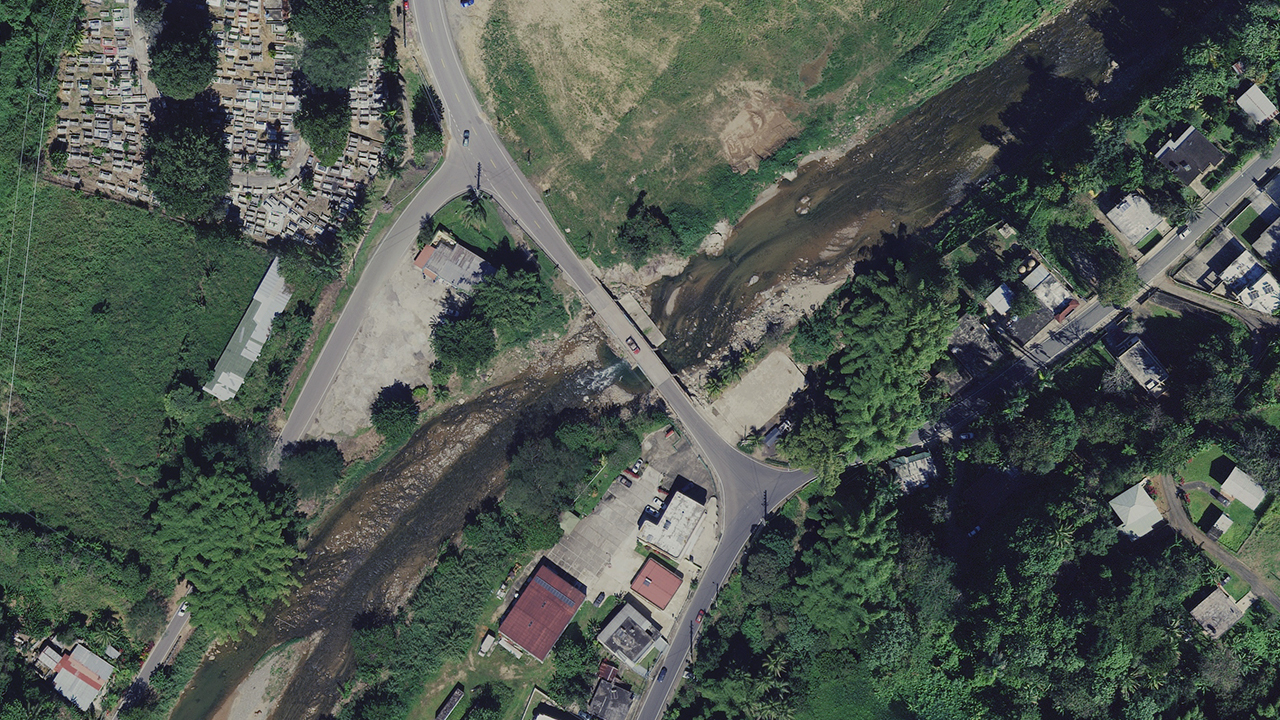
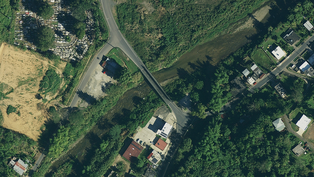
Figure 1. Aerial imagery of a bridge over the Guaonica River in Utuado, Puerto Rico, in 2017 (left) and 2022 (right). (Source: Hexagon)
His reports described the bridges that no longer existed so that plans and budgets could be made to construct new ones, with prioritization of those on major travel routes. More detailed construction plans would be needed later, but for the quick, initial assessment the imagery was ideal. Martinez added that engineers relied on the assessments in some cases to determine how to design bridges better suited to withstand future storms.
Martinez recalled how the sharpness and clarity of Hexagon’s aerial imagery made it easier for him to accurately identify assets and determine their condition across the island. This was in contrast to his experiences with free GIS basemap images that suffered from haziness, distortion, and poor geometric alignment, especially in rural areas.
The HxGN Content Program devises stringent aerial collection and processing procedures to ensure consistently high resolution and accuracy from one geographic area to the next and from one time period to the next. This superior quality is due to airborne collections only during high-sun-angle, haze/cloud-free conditions. Standardized ground processing workflows deliver uniform photogrammetric and radiometric quality regardless of acquisition location.
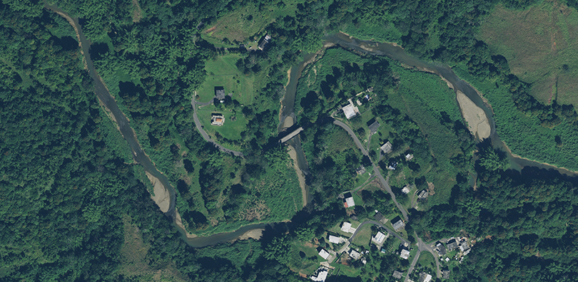
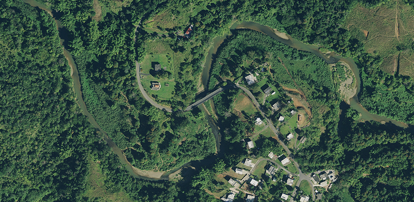
Figure 2. Aerial imagery of a bridge over the Culebrinas River in Moca, Puerto Rico, in 2017 (left) and 2022 (right). (Source: Hexagon)
Disaster recovery and planning continue in Puerto Rico
In many ways, recovery from Hurricane Maria has become a preparation for future Caribbean storms and other catastrophes. One such project was a power grid mapping initiative by the Puerto Rico Electric Power Authority (PREPA), now managed by LUMA Energy. Its contractors used updated Hexagon aerial imagery to locate transmission and distribution lines and assess the condition of towers throughout the island.
When PREPA’s grid was rebuilt after Maria, the work was assigned to the U.S. Army Corps of Engineers by FEMA. U.S. government guidelines sometimes require the placement of power lines and support structures in locations other than the original ones. This was done to avoid environmentally sensitive habitats. Reconstruction proceeded at such a rapid pace that detailed maps of the new infrastructure locations were not created.
“With 15-centimeter imagery, they can see the towers and count the lines from their offices,” said PRX’s Melendez. “For a person to evaluate one tower in the field, particularly in the rural areas, can take up to eight hours – this is a huge time savings.”
Use of the Hexagon aerial imagery has expanded in the private and public sectors since Maria, explained Martinez. He has since moved from the DOT to a private firm called Metric Engineering of Puerto Rico, which he recommended to purchase the streaming of Hexagon’s aerial imagery through PRX.
Heavily involved in transportation projects, Metric Engineering routinely relies on the imagery as the base layer upon which new road configurations are designed. Adding a new lane, for example, first requires Martinez to analyze the images to inventory existing signposts, guard rails, lane markers and other assets that will be impacted by the expansion. CAD drawings are overlaid on the images to perform the actual design of the new construction.
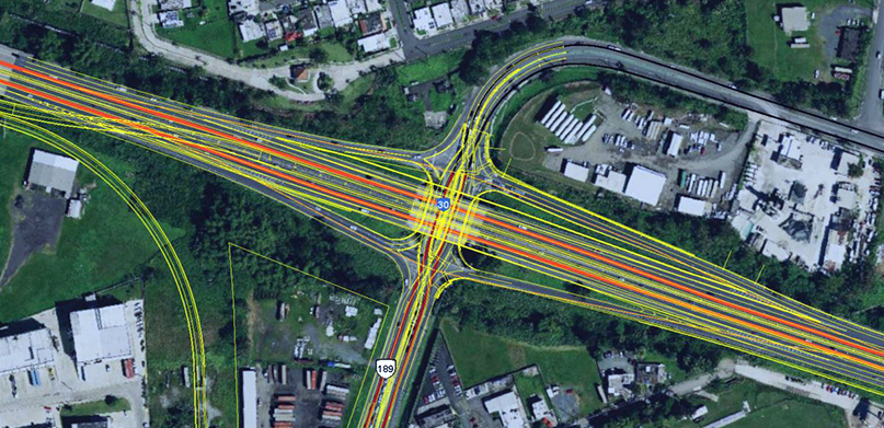
Figure 3. CAD drawing overlaid onto Hexagon’s 15 cm aerial imagery. (Source: Metric Engineering)
Martinez continues to be amazed at the geometric accuracy of the image data and the speed with which they are deployed. “Everything aligns very smoothly and perfectly,” he said.
PRX is currently introducing the 2022-2023 HxGN Content Program refreshed aerial imagery to clients in Puerto Rico. “Whether in normal day-to-day operations or in response to an emergency, the value of quality imagery lies in the power of informed decision-making,” said Melendez.
For more information on Hexagon’s HxGN Content Program, visit our website or follow us on LinkedIn.