


Aerial data provides a detailed visual representation of the world around us, serving as a powerful solution to spatial analysis and addressing critical challenges across various industries. Hence, it has become an indispensable resource for professionals and decision-makers in many fields, especially surveying and land management.
In surveying, aerial imagery enables accurate measurement and mapping of land features, aiding in property boundary determination and infrastructure planning. In land management, it provides valuable insights for assessing vegetation health, monitoring changes in land use and supporting conservation efforts.
Hexagon has produced detailed aerial data of buildings, infrastructure and vegetation as part of Denmark’s summer digital orthophoto collection, which organisations nationwide use in their daily work. We interviewed three members of the Association of Chartered Land Surveyors, also known as Praktiserende Landinspektørers Forening (PLF) in Danish, to learn how their respective organisation has leveraged Hexagon’s high-resolution aerial imagery over the years. PLF is a trade association of chartered land surveyors in Denmark with a network of over 1,400 members. The association is part of the International Federation of Surveyors (FIG) and the Council of European Geodetic Surveyors (CLGE).
The three surveying and consulting firms vary in size, ranging from eight to 450 employees. Their customer base includes private homeowners, developers, utilities, municipalities and government agencies requiring guidance on land management, land use potential and boundary delineation. The companies conduct cadastral surveys for determining boundaries between plots of land, as well as more technical ground mapping surveys for new infrastructure projects. Hexagon’s aerial imagery supports all these tasks – as the customer interview excerpts below attest.
Skel.dk: High-accuracy maps for better land management
Skel.dk is based in Zealand and Jutland and employs around 100 people. Michael Staerk, chartered surveyor at Skel.dk, took part in establishing Skel.dk landinspektører P/S in 2012 through a merger of two surveyor companies.
Q: What do you consider the main benefits of a comprehensive dataset of high-resolution aerial imagery?
Michael Staerk: A few decades ago, obtaining data for mapping was challenging. We had to use paper maps, which were not very accurate, and collect manual data from small municipalities. Hexagon’s aerial imagery has been a game-changer due to its comprehensive coverage and high accuracy. The pixel size (resolution) and the placement accuracy are crucial. For example, when advising homeowners or businesses, we utilise Hexagon aerial images to compare property boundaries with the actual on-ground situation, as mandated by Danish regulations. In doing so, we often find mismatches between the registered property borders and the actual situation in the aerial photos – discrepancies that the respective owners need to resolve through negotiation. The availability of high-accuracy mapping data has been transformative in simplifying mapping processes and clarifying boundary disputes. A key advantage of Hexagon’s orthophoto collection is that survey flights are always conducted during the same time of year, which ensures they occur under identical seasonal conditions each time.
Q: Skel.dk works with a dataset that spans several decades. What role does historical aerial imagery play in your work?
Staerk: Having access to aerial photos spanning several decades is crucial in our line of work. An example is boundary disputes. Danish law stipulates that if a situation (such as a fence encroaching on a neighbour’s property) has persisted for over 20 years, the encroaching party can claim ownership. Meanwhile, historical aerial imagery plays a vital role in documenting land and property changes over time. For example, Skel.dk consults Hexagon’s historical aerial photos to determine changes in land features, buildings and property boundaries. The vintage data offers important reference points – such as objects that haven’t moved for perhaps a century – that can be used to determine relative positioning and changes.
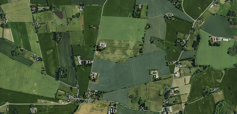
15-centimetre aerial image of agricultural land in Denmark. (Source: Hexagon)
LE34: Hexagon’s aerial imagery brings maps to life
LE34 maintains 23 offices across Denmark and provides surveying services across the country. Torbjørn Mandahl Pedersen works as a chartered surveyor and is also a partner in LE34.
Q: Can you give some specific examples of how aerial imagery supports the work of LE24?
Torbjørn Mandahl Pedersen: LE34 has been using aerial imagery for a range of purposes since the mid-1990s. Internally, the images are an important quality assurance tool to verify that everything within a given area has been measured accurately. For infrastructure projects like laying new pipes, negotiations with landowners are required. Hexagon’s aerial imagery supports these discussions by providing a clear backdrop for explaining proposed infrastructure changes. We like to add images as a backdrop to customer deliverables. For example, the images help illustrate what has been measured in field measurement documentation.
Q: What distinguishes aerial imagery from other ways of capturing landscapes?
Pedersen: Aerial imagery is intuitive and aligns with people’s real-world perceptions. Before we had access to aerial images, LE34 relied on technical maps, which were more challenging for clients to understand. We find that a lot of customers struggle to interpret traditional maps. With the aerial image in front of us, we can talk to the customer as if we were in the field together. This makes communication with the client very easy. Although the Danish government provides aerial imagery for free, we like to use Hexagon’s images because they are visually more appealing to clients. The images are taken in the summer, and the green trees make for a nice backdrop. We also appreciate the fast accessibility and reliability of Hexagon data. We cannot recall a single instance where the service was down.
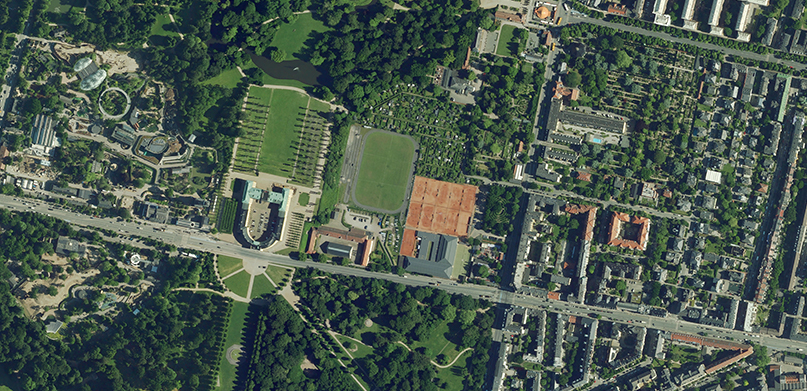
15-centimetre aerial image of the Frederiksberg Palace and the surrounding area. (Source: Hexagon)
Kjaer: Resolving boundary discrepancies from the air
Kjaer is a local traditional surveyor company in Grenå, Denmark’s Djursland area, specialising in local cadastral work. Morten Knudsen works as a chartered surveyor at Kjaer.
Q: Since when have you been working with aerial imagery, and what data did you rely on previously?
Morten Knudsen: Kjaer has relied on Hexagon’s aerial imagery since it first became available in 1995. Prior to that, we used old aerial photos from survey firms – tracking them down was often a cumbersome and time-consuming process.
Q: Besides ease of access, what are other advantages of using aerial imagery?
Knudsen: For Kjaer, aerial images are instrumental in planning technical surveys, conducting cost assessments for proposals, understanding the broader physical environment, and even serving as backdrops for various map types. The online accessibility of Hexagon’s aerial images enhances their utility, offering immediate references when exploring new areas. Working with a dataset that spans almost three decades allows us to document historical land use – a crucial feature considering the Danish legal landscape. Under Danish law, if an individual or entity has occupied and used a plot of land for over 20 years, they can claim it, irrespective of whether they are the registered owner. Hexagon’s aerial imagery thus plays a critical role in land claim validations.
About Denmark’s Digital Orthophoto (DDO) Program
In an era where data-driven decision-making has become the cornerstone of progress and development, Hexagon’s DDO program is a remarkable testament to the power of technology and innovation. The DDO program produces detailed images of buildings, infrastructure, vegetation and more, providing both a comprehensive overview of large areas and specific detailed information. The high resolution of the imagery allows for the identification of even the smallest details when zooming in on a place while also providing a quick overview.
The DDO program has added valuable data to the documentation of Denmark’s development since 1995. It’s reliable data collection every two years has enabled municipal administration and planning, land optimisation, boundary delineation and more for nearly three decades.
Visit our webpage to learn more about Denmark’s Digital Orthophoto Program by Hexagon.