


Based in Columbus, Ohio, RoofSnap is a leading roofing software application used by contractors to create fast, accurate roof measurements and job estimates for customers. The solution stands out in its ability to support contractors working anywhere in the United States – thanks to countrywide aerial imagery from Hexagon’s HxGN Content Program.
RoofSnap is among the only roofing applications that serve contractors outside major urban areas. The company has achieved its nationwide status by utilizing Hexagon’s orthorectified high-resolution aerial imagery in suburban and rural regions from the HxGN Content Program, which provides coast-to-coast coverage of the contiguous United States, as well as Hawaii and Puerto Rico.
“RoofSnap exists to make the roofing contractor’s life easier by streamlining their sales process,” said Scott Noll, President of RoofSnap. “Having coverage in rural areas and the ability to quickly turn around an accurate measurement offers roofing professionals a competitive advantage.”
Roof measurements in a snap with Hexagon’s aerial imagery
Accessible from the office or in the field, the RoofSnap application is often used to measure potential customers’ roofs to develop work estimates for repair or replacement. The contractor simply enters an address, and RoofSnap retrieves a high-resolution aerial image of the residential structure. The software offers the option of measuring the roof surface automatically using its measurement ordering service or allowing the user to do it manually using DIY tools.
The DIY tool enables contractors to trace the roof outline on the aerial image and enter important details, such as the shape and pitch of the entire surface or parts of it. The software takes this data into account to calculate a more accurate measurement of the surface area than could otherwise be made from the 2D image alone.
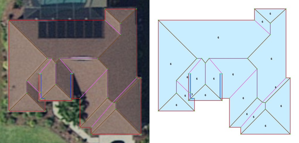
RoofSnap’s measurement reports include a pitch diagram and Hexagon’s aerial image of the property. (Source: RoofSnap)
Another valuable RoofSnap feature is its estimating capabilities. The application lets the contractor input costs related to variables such as personnel time, material prices, and other factors to generate a precise job estimate that can be provided to the prospect onsite. If the estimate is accepted, the application also allows the user to tag the aerial image with notes pinpointing and describing roof damage, access problems, or other conditions discovered on-site to make the job proceed more smoothly.
“We use Hexagon’s rural aerial imagery daily to complete measurements but are most proud of Hexagon’s contribution to the over 38,000 measurements we’ve been able to complete during hurricane season,” said Noll. “This partnership enables RoofSnap to provide homeowners, impacted by severe storm damages, the government support they need to shelter in place until their damage is fixed.”
Reliable aerial imagery for roofers on the go
The HxGN Content Program employs extensive ground control throughout the United States to tie its aerial imagery to real-world coordinates. This means the pixels are placed more precisely to their actual locations on the roof surfaces, resulting in more accurate measurements for the contractor.
“Hexagon’s complete coverage of the contiguous United States enables contractors to visualize as-built conditions of rooftops anywhere in the country,” said Rob Eadie, Partner Manager at Hexagon. “In addition, our high-resolution orthorectified imagery has superior geometric positional accuracy, enabling contractors to have more confidence in their measurements.”
As a streaming subscriber to the HxGN Content Program, RoofSnap customers will always have access to the latest high-resolution aerial imagery. Hexagon’s cloud-based imagery streaming service is continually updated so that existing GIS or enterprise platforms have access to the latest information. The streaming service is provided as a mapping API in standard protocols (WMTS, WMS, ArcGIS REST, and SOAP).
For more information on Hexagon’s HxGN Content Program, visit our website or follow us on LinkedIn.