


The Rancho California Water District (Rancho Water) serves a population of over 150,000 residents across a 100,000-acre expanse, encompassing the city of Temecula, portions of the city of Murrieta, and unincorporated areas of Riverside County. Situated southeast of Los Angeles, the district’s water and wastewater services are distributed through 39 reservoirs, drawing from both natural and treatment facilities.
In accordance with mandates from the California Department of Water Resources (DWR), Rancho Water adheres to responsible, sustainable water use procedures in its daily operations. In times of drought, however, even more stringent protocols are adopted. This was the case in early 2023 when Rancho Water’s service area – like much of the state – faced the aftermath of prolonged periods of low precipitation and recurrent drought conditions, exacerbated by climate change. These conditions underscore the urgent need for water agencies to use water more wisely and prepare for more frequent and persistent periods of limited water supply.
As part of its initiative to comply with water conservation legislation and prepare for a forthcoming rate study aimed at setting water rates, the district undertook a project to identify non-functional turf areas through its service area. Additionally, the analysis aimed to pinpoint water needs associated with various land cover types identified down to and within individual parcels.
For support in producing parcel land cover classification and irrigated area measurement maps for the entire district, Rancho Water contracted with DCSE Inc. of Laguna Hills, California, a resale partner of Hexagon’s HxGN Content Program. DCSE is an engineering, GIS, and IT consulting company that specializes in developing water, wastewater, and sustainability solutions for utilities and government agencies. The firm initiated the Rancho Water project in Spring 2023.
Classifying land cover types for water conservation
California water sustainability efforts involve engagement with citizens at all levels, and residential homeowners play important roles in these activities.
Since private homes, especially those with grass yards, are major consumers of water, the calculation process focuses on identifying and measuring the areas of trees, turf, pools, roofs, bare land, impervious surfaces (e.g., driveways, patios), and artificial turf in each single-family residential parcel. This information is used to establish watering schedules and even to administer turf replacement and rebate programs for homeowners.
In addition, the district was required to identify non-functional turf areas, which are often decorative grasses on median strips and in the plazas of commercial and industrial sites. Unlike yards in residential properties, non-functional turf serves no specific purpose other than aesthetics. These areas are vital for land cover measurements and conservation efforts in the state, as recent legislation prohibits the use of potable water for irrigating them, even outside of drought conditions.
DCSE had worked on similar DWR-mandated projects in the state and knew how to approach the land cover calculations based on previous experience. For an earlier similar assignment, the firm obtained free image data from the U.S. Department of Agriculture. Created from airborne acquisitions, this four-band (RGBN) raster data set offers a 60-centimeter spatial resolution.
The remote sensing analysts at DCSE applied machine learning classification models to the free data to differentiate the desired land cover types. The process identified the desired land cover classes with an average 94 percent accuracy rate. However, when the scientists took a closer look at the results, they saw a problem. Grass turf and trees were being confused with one another at unacceptable rates, averaging classification accuracies of 85 to 93 percent. The similar spectral signatures of healthy grass and deciduous trees caused this misclassification.
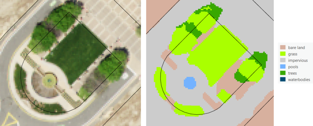
Figure 1. When 60-centimeter resolution aerial imagery (left) was used to generate a land cover map (right), the model misclassified the trees as grass. (Source: DCSE, Inc.)
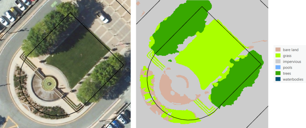
Figure 2. After leveraging 15–centimeter aerial imagery and elevation data, the misclassified trees in Figure 1 were classified correctly and the turf areas, such as the narrow strips of decorative turf, were shown in more detail. (Source: DCSE, Inc.)
“Those are good results but not great, especially at the parcel level,” said Dr. Tarlan Razzaghi, Remote Sensing Manager at DCSE. “Combining irrigated turf and trees into one class is actually acceptable for DWR requirements, but some districts want grass/turf only as a separate class.”
Rancho Water was one of those districts that wanted precise turf area measurements for two important reasons. Firstly, this analysis enables the district to identify eligible customers for financial assistance in removing turf from their property and replacing it with climate-appropriate plants that support local ecosystems. The Turf Replacement Program determines incentive amounts based on the square footage of the turf replaced. Secondly, in anticipation of complying with state regulations that prohibit the irrigation of non-functional areas, the district required accurate measurements of this class for preparational purposes.
Saving water with higher-quality aerial data
Due to the heightened accuracy requirements of Rancho Water, DCSE opted to process higher-quality data sets from the HxGN Content Program. Having refreshed the entire state of California in 2022, this expansive library of high-resolution aerial imagery and elevation data is known for temporal consistency and high accuracy across large geographic areas due to airborne collections only during high-sun-angle, haze/cloud-free conditions.
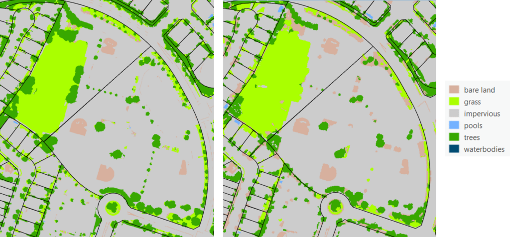
Figure 3. Land cover classification is more precise using 15-centimeter resolution imagery (right) compared to when 60-centimeter imagery was used (left). (Source: DCSE, Inc.)
DCSE obtained Hexagon’s 15-centimeter, four-band aerial orthoimagery covering the district along with a 15-centimeter digital surface model (DSM). The scientists applied the same classification models to differentiate classes based on spectral signatures in the orthoimagery. However, they also created and applied a height filter using the DSM data. This separated the turf and tree based on their height in the DSM, where five feet was used as the threshold differentiator.
“With the higher-resolution HxGN Content Program aerial imagery and 15-centimeter DSMs, the accuracy for both turf and tree classes exceeded 96 percent,” said Razzaghi. “In addition, the precision of the land cover class surface area measurements improved as well when the more detailed 15-centimeter Hexagon imagery was used compared with the free 60-centimeter data.”
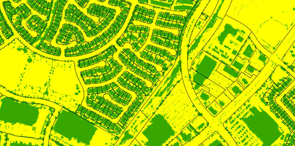
Figure 4. The model applied a height filter using DSM data where the yellow areas represent land cover under 5 feet and the green areas show greater than 5 feet. (Source: DCSE, Inc.)
“The accurate classifications and measurements provided by Hexagon’s high-resolution imagery and elevation data enable districts to fulfill state mandates while also delivering fair and equitable services to our water users,” said Liviu Rosu, GIS Coordinator at Rancho Water.
DCSE delivered the classification data to Rancho Water through vectors and spreadsheets. The firm tabulated all results at the level of individual parcel polygons. When input into the district’s GIS application, the classes and measurements were matched to specific property addresses. Additionally, the district could categorize turf classes on non-residential parcels as non-functional turf.
“Enhancing sustainability, as demonstrated by the Rancho Water project, is a priority for the solutions Hexagon builds for critical industries worldwide,” said John Welter, President, Geospatial Content Solutions, at Hexagon. “Our goal is for clients to make smarter use of Earth’s resources by unleashing data to do its greatest work.”
For more information on Hexagon’s HxGN Content Program, visit our website or follow us on LinkedIn.