A version of this article originally appeared on Business Geomatics and has been translated here into English.
The Great Library of Alexandria was created in the third century B.C., enabling the systematic provision of knowledge and information for the first time. The Library not only guaranteed the supremacy of the former Macedonian Empire under Alexander the Great, but the now Egyptian city also replaced Athens as the leading center of science. For the first time, the world experienced how important standardized availability and accessibility of cultural assets could be for the further development of humanity.
As old as the historical example may be, there are analogies with the current geospatial information sector. Until now, geospatial data and the knowledge built on it was largely recorded regionally or, at best, nationally. Heterogeneous and distributed data is still the rule, not the exception. At the same time, the need for national and transnational standardized data (i.e. a type of universal library of geospatial data) is growing constantly. Map services from large tech companies even require this on a global level. Network operators, utilities or navigation professionals are also increasingly requiring standardized data for large areas which would involve significant resources for research, procurement, and data consolidation.
Providing content since 2014
Hexagon introduced the HxGN Content Program in 2014 with precisely this goal in mind. Initially, the company offered aerial imagery and derived data products for the United States. This was the first time that data from aerial surveys was offered in a standardized format. “All data products fulfil the highest accuracy requirements, both horizontally and vertically,” states Michaela Neumann, Market Director Europe at Hexagon. “They are also quality-assured on all levels and thus meet the requirements of our customers.” Hexagon has defined the quality standards for all steps of the data capture process, starting with planning the flights, through to the provision of the data. “We offer complete transparency. Customers can evaluate the data quickly and it costs less than custom contracting, which is still common practice in many sectors,” states Neumann.
Data performance and accuracy
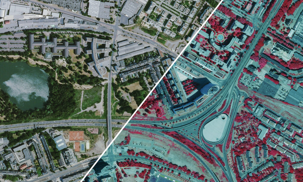
24 million square kilometers of European data has been collected and made available since 2015, which is the largest airborne imagery database in the world. The data products are orthorectified, available in different resolutions and include multispectral orthophotos, stereo images, DSM’s and DTM’s. Hexagon offers further products on request.
Currently, the data resolution offered in Western Europe is largely 30-centimeter resolution or GSD (ground sampling distance). The resolution is getting successively better. In the United States, for example, data with a resolution of 15 centimeters is already available across entire states. For data parameters such as spatial resolution and collection frequency, Hexagon aims to react flexibly to the demands of the market. In Denmark, for example, the resolution is already at 12.5 cm across the country.

True-color orthophoto on the left; color-infrared on the right.
Expanding the strategy
Establishing the data program was a major decision for Hexagon. The company is a global leader providing airborne sensing technology and offers the innovative sensor, Leica CityMapper-2 (currently in the second product generation), which is the world’s only airborne sensor that simultaneously captures LiDAR and oblique imagery, and Leica HxMap offers a unified post-processing software. With the HXGN Content Program, the company has created a completely new product offering. Previously, the aerial imagery market was largely a project business, where service providers captured the data based on custom contracts.
Partners are important for Hexagon
Hexagon chose a flexible data capture strategy. Next to its own aircraft fleet, the company established a comprehensive network of data capture and resale partners. Flight partners currently capture around 60 percent of the coverage area. Resale partners act as distributors which end customers can approach directly to purchase products. Three-quarters of the data is currently sold through partner channels. “A close and stable cooperation with our partners is very important to us,” stresses Neumann.
AI analysis improved through standardized data
Providing standardized data is also important to aid modern analytics tools. Although AI-based analysis of imagery is well advanced, the challenge lies in training the algorithms. If the aerial imagery is inconsistent, the algorithms require more extensive training and the results become less useful. “It’s precisely this AI weak point that Hexagon overcomes with the Content Program. The extraordinarily high consistency creates optimal training conditions and paves the way for large-scale mass analyses and feature extractions,” states Neumann.
Small data packages are available
Customers can purchase data with any geographical coverage: The minimum order is EUR 82, which covers an area of 9 square kilometers. Data provision is also completely flexible. Hexagon delivers data traditionally via hard drives (for extremely large data volumes) or via streaming service, which can be integrated into the customer’s GIS software, apps, and databases. “We can push it so far that our users don’t even have to set up memory space at all. They can immediately process the data in real-time and on the cloud,” states Neumann.
Since customers purchase the data via a subscription model, they always receive the latest imagery. Hexagon is currently aiming for an update cycle of two to three years. However, the company is flexible to accommodate special requests for data capture and processing.
To learn more about Hexagon’s HxGN Content Program, please visit hxgncontent.com.


