


Current developments in artificial intelligence (AI), machine learning (ML) and cloud computing enable more efficient and effective analysis of big data. Companies and organisations around the world are successfully using orthophotos, stereo imagery and derived elevation data sets individually and in combination with AI and ML to glean actionable information. Applications include asset management, risk assessment, emergency response and environmental monitoring, as well as the design and construction of transportation, utilities, and telecom infrastructure.
With the right tools, high-resolution imagery delivers a wealth of valuable information; however, the best results require accurate and homogeneous data over the area of interest. Along with its enormous coverage, feature rich data and flexible use terms, the HxGN Content Program offers the perfect data set to train algorithms designed to automatically extract information critical to a multitude of applications.
Machine-learning-ready geodata for AI/ML
The process of training machines to automatically identify and extract certain features relies on spatially accurate, high-resolution imagery with consistent radiometric quality and minimal clouds and shadows. The process of training algorithms is often considered an overhead process in a project’s lifecycle. Thus to maximise revenue, the idea is to minimise training site selection to small areas that adequately represent the overall area of interest. If done correctly and with optimised data, these small training sites facilitate the algorithms’ ability to confidently process the data for its true intended purpose at scale. Therefore, it is crucial that a feature in one portion of the image (e.g. training) be consistent with a similar feature in another region (e.g. target or non-training). Highly consistent data ensures locally trained algorithms apply globally, meaning lower overhead with increased results and revenue.
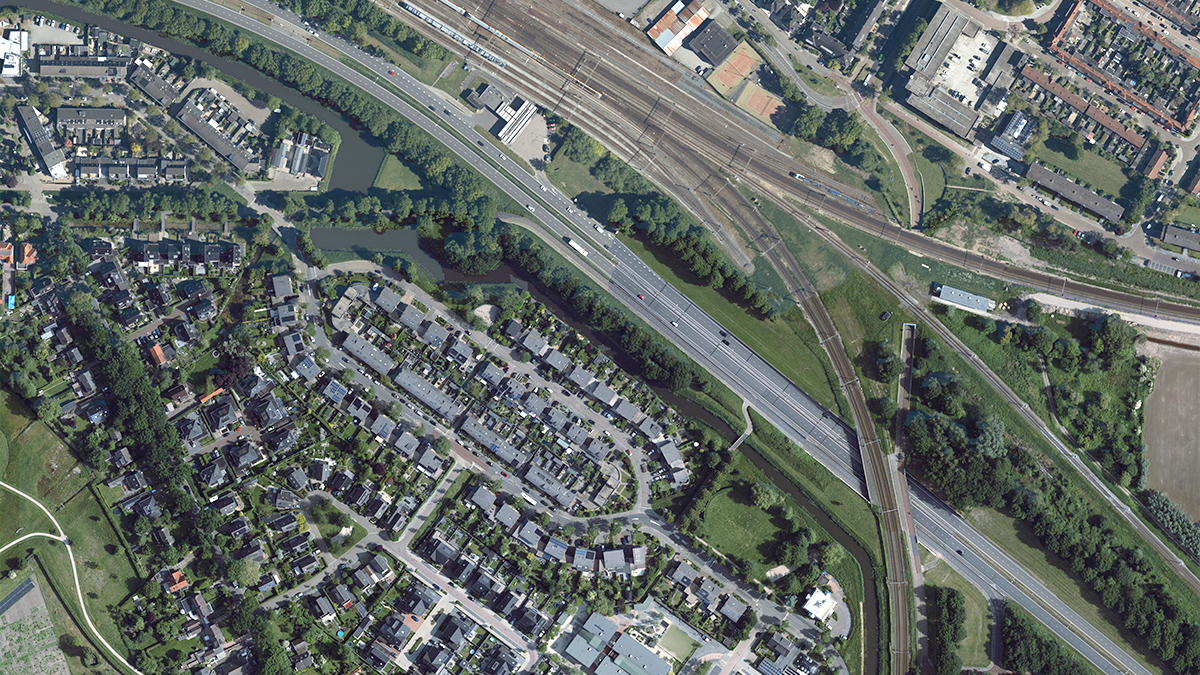
Hexagon leverages its own high-quality aerial imagery to develop analytics products in house by training algorithms for automated feature extraction of various thematic layers. The large-area coverage of the HxGN Content Program produces homogeneous imagery and elevation products that meet the stringent quality requirements of AI/ML processing. Companies in the AI/ML space can also leverage the program’s aerial imagery to produce derivative products without excessive restrictions. For ease of use, 4-band (Blue-Green-Red-NearIR) data is delivered machine-learning-ready in a variety of formats, resolution and coordinate reference systems. The program’s photogrammetric quality data is scalable from local to continental coverage and can be purchased through an online store or streamed directly into third-party GIS software, customised software or web applications via WMS/WMTS protocols. This saves our customers time and cost for storing, hosting, using and distributing the data internally.
“We make it easy for customers to access and work with our data,” says Trevis Gigliotti, Content Product Manager. “Our processing centres in North America, Europe and Asia minimise turnaround time, and distribution centres around the world deliver or further customise products to meet customer needs.”
More detail yields better insights
Hexagon controls the entire HxGN Content Program workflow, including the design, development and integration of the sensors into our fleet or aircraft, scheduling data collection missions, acquiring and processing data to the highest level of photogrammetric quality. The nationwide program includes 4-band orthophotos at 15 or 30 cm GSD, along with elevation products and stereo imagery. Higher spatial resolution imagery delivered at 5 cm GSD will be coming online for select metro areas later in 2022 as well. This large-area coverage is ideal for extracting 3D information at a reduced cost.
“The HxGN Content Program serves various AI companies that have automated the feature extraction process with machine learning technology,” Gigliotti explains. “The standardised high-resolution imagery is designed to be directly integrated into customers’ solutions or serve as a basis for the generation of new products. As a reliable source for big data analytics customers, we provide multiple levels of detail, suitable to a variety of applications.”
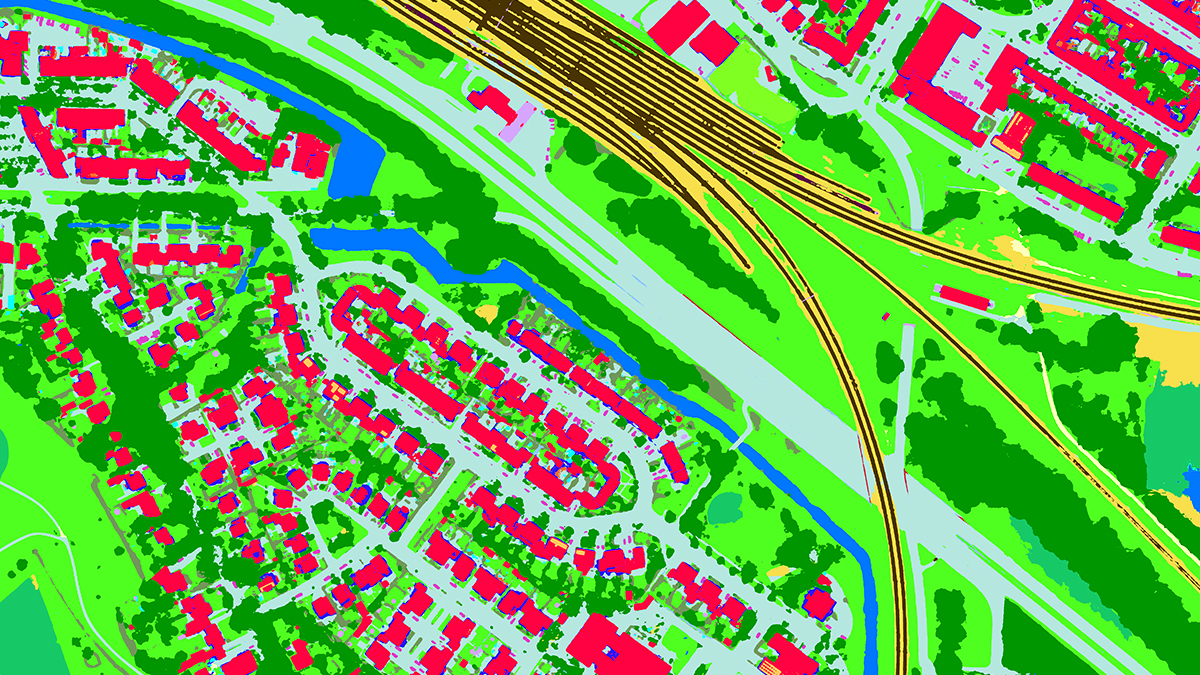
Canadian company Ecopia AI delivers insights obtained from geospatial big data. By converting the Content Program’s high-resolution stereo imagery to 2D and 3D HD vector maps, the team creates an accurate digital representation of the real world, including 14 landcover classes such as trees, bridges, swimming pools, roads, vegetation, and buildings, with 3D height attributes. The resulting 3D Nationwide Landcover map for the US is in demand for asset management, risk assessment, emergency response applications, and many other uses.
Ecopia leveraged the HxGN Content Program’s countrywide stereo imagery to create 3D Nationwide Landcover maps of the United States (Image source: Ecopia)
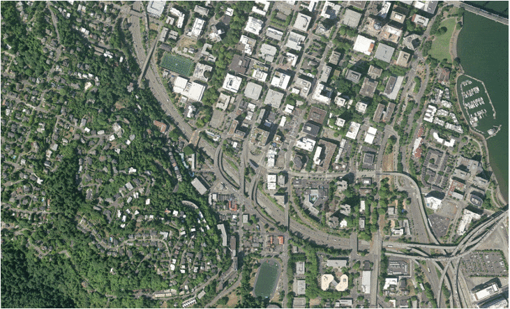
LandInfo, a United States-based company, is a pioneer in AI feature extraction and an early adopter of the HxGN Content Program. Specialising in solutions for wireless communications in the telecom field, LandInfo leverages proprietary techniques to extract and compile scalable 3D measurements from high-resolution aerial imagery and various elevation data. The growth of 5G technology is creating a huge demand for signal propagation plans and cell site mapping, which require 3D tree vectors, normalised height models, and 3D bridge models that also include attribute information on material class. In addition, radio frequency (RF) engineering models, based on imagery and imagery derived data, are used to identify the best locations for small 5G antennas and cell towers to optimise network performance.
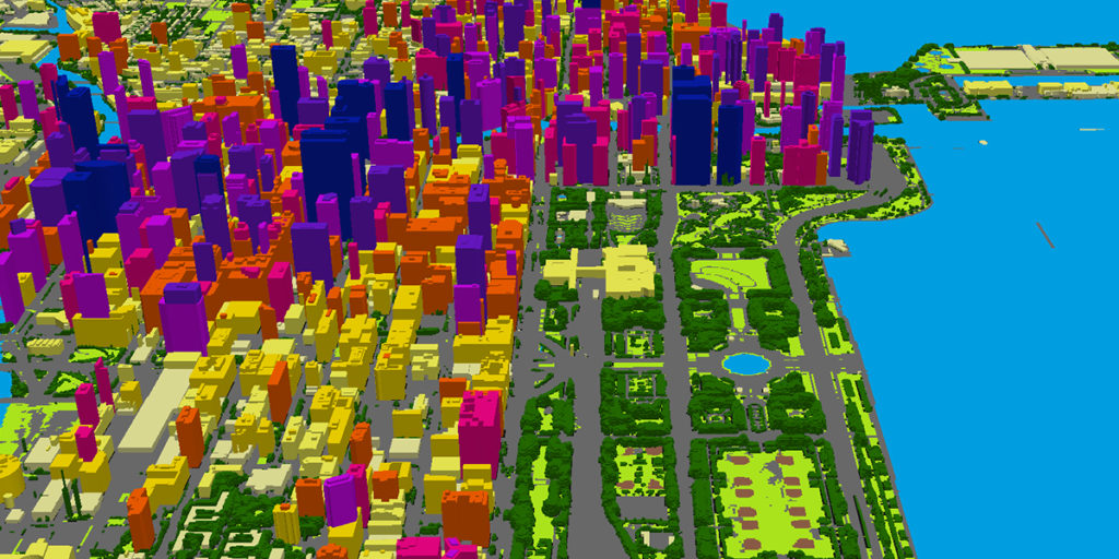
Land Info uses the HxGN Content Program’s high-resolution aerial data extract elevation and landcover information (Image source: LAND INFO Worldwide Mapping)
The full range of opportunities for artificial intelligence and high-resolution aerial imagery is still unknown; however, the benefits are not in question as helpful applications continue to be discovered. Data sets from the HxGN Content Program provide the resolution, accuracy, currency, scalability and consistency ideal for machine learning and automated feature extraction, making efficient and effective analysis of big data a reality.
To learn more about the HxGN Content Program, Hexagon’s aerial data program, please visit hxgncontent.com.