The HxGN Content Program is proud to have a network of partners to support our data acquisition, processing and selling as well as provide expertise inside the geospatial industry. Each partner brings a unique set of value-added solutions to the market to help customers optimize their data use. The Partner Spotlight Series showcases the great work of our partners.

Ecopia AI’s Profile
HQ: Toronto, Canada
Year Established: 2013
Areas of Expertise: Using AI to extract precise human and natural 2D and 3D map features at continental scales.
Solutions Overview
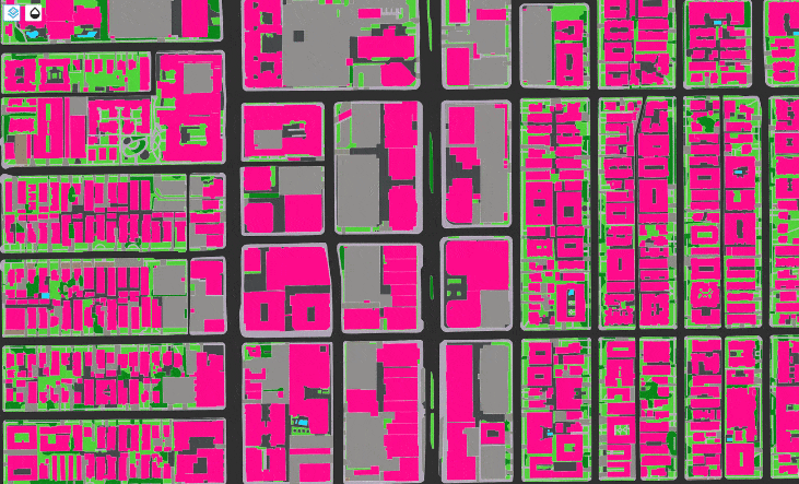
Ecopia leverages artificial intelligence (AI) to convert high-resolution images of our earth into high-definition (HD) Vector Maps. These maps form a digital representation of reality and are embedded into critical decision-making applications, offering unique insights at scale. Global feature extractions are created in less time, for less money, with the accuracy of a trained GIS professional and can be scaled across the globe using imagery from its partners, such as Hexagon’s HxGN Content Program.
Ecopia leverages a network of global imagery partners to utilize the world’s most high-resolution and up-to-date geospatial imagery to train its algorithms, as well as deliver superior HD vector maps to customers around the world. Its Global Feature Extraction services create HD vector maps that are 95% accurate, at a lower price, and in less time than human annotation. This allows businesses, governments, and non-profits to make quicker and more informed decisions based on the most accurate, comprehensive, and up-to-date digital representation of our physical world.
Hexagon & Ecopia AI’s Partnership
Ecopia relies on high-precision geospatial imagery to create its industry-leading HD vector maps, which has resulted in a strong network of imagery partners. Its partnership with Hexagon was a strategic step to maintain the integrity of its imagery partner program. Ecopia just recently launched its 3D Nationwide Landcover – a high-precision 3D vector map of the entire United States, derived from the HxGN Content Program’s 6” and 12” resolution stereo imagery. Because the HxGN Content Program offers the most high-resolution source of commercial imagery available in the US, it was the best imagery source for building the 3D Nationwide Landcover product as well as offering global feature extraction services to enterprise customers.
Ecopia’s 3D Nationwide Landcover includes every building, road, bridge, railway, driveway, crosswalk, sidewalk, parking lot, swimming pool, sports field, waterbody, forest, grassland, bareland, and other paved areas – across the US in addition to all buildings, trees, and bridges with unique height attribution. Government agencies, insurance carriers, and other enterprise users can leverage this accurate, comprehensive, and up-to-date digital representation of the US as the foundation for location intelligence and mission-critical applications.
To learn more about Ecopia AI, please visit ecopiatech.com.