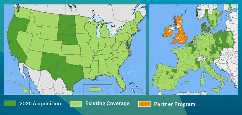
The HxGN Content Program is on track with its third refresh cycle for North America and Europe with an update of more than 3 million square kilometres of high-accuracy four-band orthophotos, digital surface models (DSM) and stereo imagery.
Vice President of Global Sales, Jamie Curtin, answers the most pressing questions about the update.
Q1. What is being updated?
A1. In North America, the HxGN Content Program will update one-third of the continental United States, including refresh of previously captured states, such as California, Texas, Oregon, North Dakota, South Dakota, Nebraska and New Mexico. In Europe, more than 500,000 square kilometres of data will be collected.
Q2. When will this new data be available?
A2. The refreshed data will be coming online in Q4 – you can check our coverage map for updates. All the 2020 data will be available on our streaming service and for download through the online store.
Q3. What’s new for the Program in 2020?
A3. We are always looking for ways to improve of data offerings and supply better imagery products to the market. For 2020, in addition to standard 30-centimetre resolution in wide areas and 15-cm resolution in urban areas that make up our typical refresh in the U.S., we chose to collect select states in full at 15-cm resolution. This new 15-cm statewide collect is the first of its kind in the U.S. market, and a transition we plan to carry forward into our future refreshes. In Europe, in addition to our established data refreshed, we are also adding new data offerings. The Danish DDO program, the premier aerial data provider in Denmark, is being offered as part of the HxGN Content Program for the first time and will cover the country at 12.5-cm resolution on a biennial refresh schedule.
Q4. Why update the data?
A4. Large-scale regular data refreshes are a cornerstone of the HxGN Content Program. Current, highly accurate data helps our customers to make better-informed decisions. Regular data refreshes also give us the ability to provide data variety to our customers. Our goal is to provide a reliable data solution that can accommodate a variety of use cases. The automotive industry, for instance, requires very high-resolution leaf-off data for street-level detail, while in telecommunications leaf-on data provides information for line-of-sight analysis for 5G network implementations. In the public sector, urban areas may need more frequent refreshes and higher resolutions of data. Ultimately, we are a customer-driven program that provides data to enable informed decision making.
Contact us to gain access to the latest and highest quality airborne data.
Jamie Curtin is the Global Sales Manager for Hexagon Geosystems, Geospatial Content Solutions business unit. Mr. Curtin has over 30 years’ experience in the geospatial industry. During his career Mr. Curtin has been involved in delivering innovative Geospatial and GIS data solutions to Government, Utilities and Telecommunications organizations across North America and Europe. In his current role, Jamie leads the sales teams for the HxGN Content Program and Airborne Sensors.


