


(Washington, D.C., U.S.A., 22 August 2023) – Hexagon’s Geosystems division today announced the immediate availability of updated high-resolution aerial data covering the entire Commonwealth of Puerto Rico and the United States Virgin Islands as part of the HxGN Content Program.
Captured during the 2021 – 2023 flying seasons, the data set includes four-band, 6-inch (15-centimeter) resolution orthorectified imagery of the Commonwealth of Puerto Rico, except Isla Mona and Isla Desecheo which are offered at 12-inch (30-centimeter) resolution. In the U.S. Virgin Islands, four-band orthorectified imagery of St. Thomas and St. John Islands are offered at 6-inch resolution and St. Croix Island at 12-inch resolution. Additionally, updated 12-inch resolution digital surface model (DSM) data of both regions are available.
“As Hexagon’s exclusive distributor in Puerto Rico, PRX is thrilled to announce the release of the high-quality orthorectified aerial imagery,” said Joel Melendez Diaz, Senior Consultant, at PRX Solutions in Gurabo, Puerto Rico. “These images are the sharpest and most up-to-date aerial data available for Puerto Rico and the U.S. Virgin Islands – with remarkably consistent quality across the islands, allowing accurate information on ground conditions.”
“Our commitment at Hexagon is to equip government agencies, organizations and professionals with the spatial detail they need to build a safer, more resilient future,” said John Welter, President, Geospatial Content Solutions, at Hexagon. “We make the necessary data readily available to swiftly execute response plans, conduct search and rescue missions, and help reduce vulnerability to future incidents.”
Historically, aerial imagery from the HxGN Content Program has served as critical baseline data sets showcasing unbiased records of property and infrastructure conditions prior to events such as Hurricanes Irma and Maria in 2017 and the earthquake of 2019. The imagery has provided a unique perspective for emergency preparation, response and management. Now, the newly available imagery will serve these same needs for future events and even for Hurricane Fiona that occurred in September 2022.
“Accurate, high-resolution data can make all the difference in thoroughly preparing for and responding to disasters and emergency situations,” added Welter. “It’s a critical resource for decision-makers when supporting people and communities in times of devastation and loss.”
In addition to emergency management, HxGN Content Program aerial imagery is used extensively in engineering, agriculture, utility, mapping and AI/machine learning applications. Throughout much of the past decade, Puerto Rico has relied on Hexagon’s aerial data products to address today’s most challenging problems in the private and governmental sectors, from public health planning and climate response to asset management and risk mitigation.
The HxGN Content Program offers an expansive library of high-resolution aerial imagery, elevation data, 3D models and analytics of North America and Western Europe. A hallmark of the data sets is their consistency in resolution and accuracy across large geographic areas due to airborne collections only during high-sun-angle and haze/cloud-free conditions. In addition, Hexagon has standardized ground processing workflows to ensure uniform photogrammetric and radiometric quality regardless of acquisition location.
The refreshed Puerto Rico and U.S. Virgin Islands orthoimagery and DSMs are available now through a streaming subscription using standard mapping APIs or via pixel download on the Hexagon Digital Reality (HxDR) Data Store, the new online store for purchasing aerial data from the HxGN Content Program.
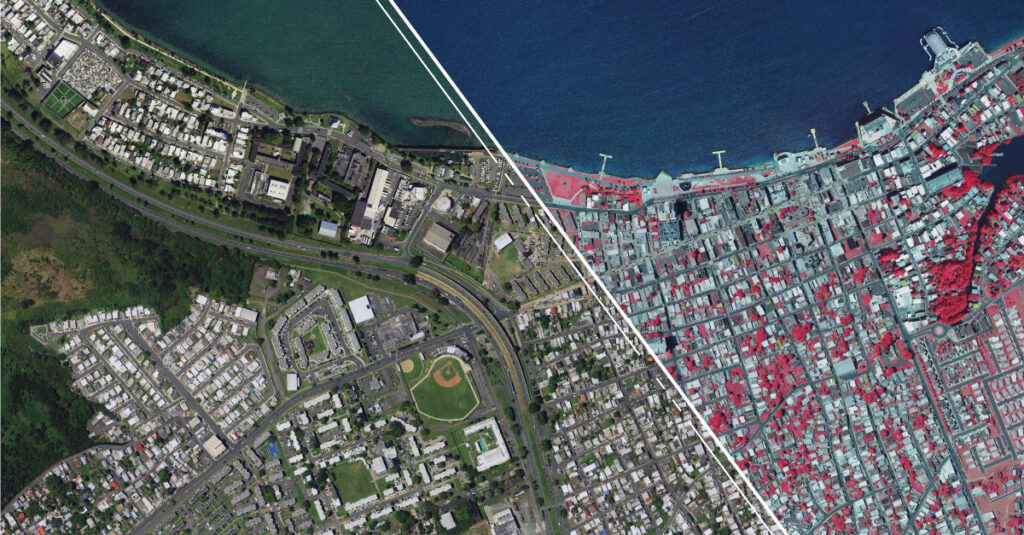
6-inch resolution RGB and CIR orthoimage of Cataño, Puerto Rico.
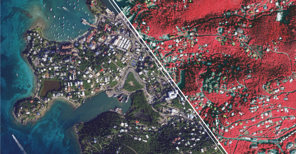
12-inch resolution RGB and CIR orthoimage of St. John, U.S. Virgin Islands.
About Hexagon
Hexagon is the global leader in digital reality solutions, combining sensor, software and autonomous technologies. We are putting data to work to boost efficiency, productivity, quality and safety across industrial, manufacturing, infrastructure, public sector, and mobility applications.
Our technologies are shaping production and people related ecosystems to become increasingly connected and autonomous – ensuring a scalable, sustainable future.
Hexagon (Nasdaq Stockholm: HEXA B) has approximately 24,000 employees in 50 countries and net sales of approximately 5.2bn EUR. Learn more at hexagon.com and follow us @HexagonAB.
About PRX Solutions
PRX Solutions is the Geospatial Information and Technology Consulting division of PRX, Corp. and is the exclusive distributor of world leading software and mapping data from Leica Geosystems. It has emerged as a Turnkey Solution Provider for Puerto Rico, U.S. Virgin Islands and Dominican Republic.