


Discover how a statewide orthoimage basemap supports the deployment of the Kansas emergency service call system.
The Kansas 9-1-1 Coordinating Council developed a program to deploy NG9-1-1 throughout all 105 counties within the State. The Council established a 9-1-1 Administrator position and numerous technical and support committees to execute the requirements of this ongoing initiative.
The Council established GIS goals and a standard set of data layers that required statewide coverages that were consistent, current, authoritative and standardized. Key to the implementation was performing a GIS GAP Analysis and Data Enhancement. To accomplish this, the Council contracted for a statewide GAP Analysis of existing GIS data and selected five GIS providers to begin the GIS Data Enhancement and Remediation based on the results of the GAP Analysis.
To meet the established GIS Goals, the Council immediately identified the need for a statewide ortho imagery layer. The ortho imagery was needed to support the GAP Analysis and Data Enhancement and provide an authoritative reference layer for call taking and dispatch within the public safety answering points (PSAPs). The imagery provides a current and consistent base map to be leveraged by state and local GIS programs with the added benefit of providing a significant economy of scale by conducting one statewide project.
The Council posted an RFP on March 31, 2014 with an extremely ambitous schedule to meet the goals of the NG9-1-1 plan. The schedule for imagery delivery consisted of six regions based on priority needs. The RFP required delivery of the data in hard formats as well as a web hosting service and included the provision for data licensing.
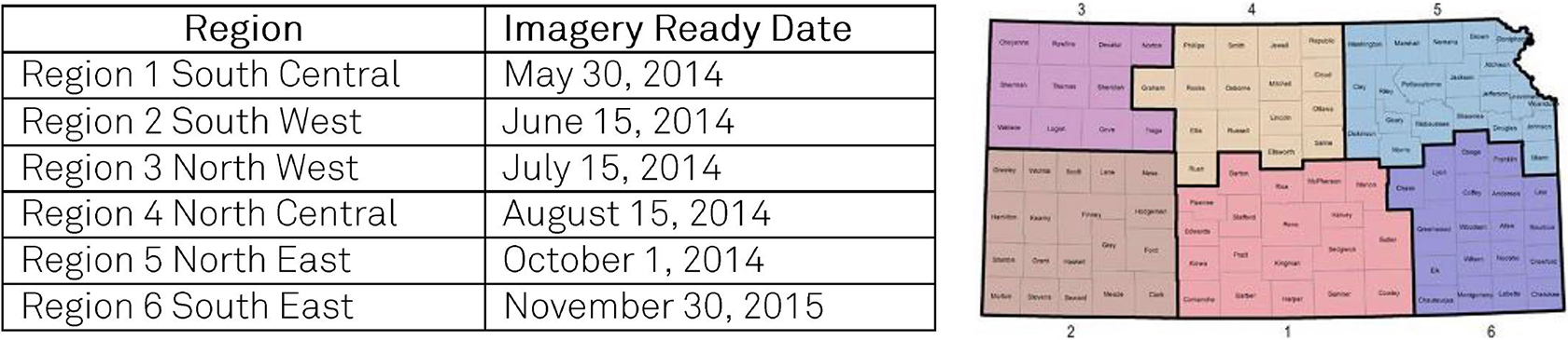
Aerial acquisition firms North West Geomatics and Surdex Corporation were selected to provide the imagery content to fulfil the statewide orthoimagery requirement, with web services to be provided by the Valtus Imagery Services. The HxGN Content Program provided statewide, 1 foot natural colour and colour infrared orthoimagery using the Leica ADS100 airborne digital sensor. Due to the availability of the HxGN Content Program, the ambitous delivery schedule was achieved allowing the GIS remediation vendors to quickly begin work to meet the overall schedule of the programme.
The licence agreement allows access to the HxGN Content Program imagery data to:
• State, county and municipal government departments
• Regents’ institutions
• All public school districts
• Any firm doing work on behalf of these entities
The web services being provided by Valtus Imagery Services include OGC WMS with authentication and support for Esri Java Script API.
The NG9-1-1 Project is one of the largest 9-1-1 and GIS initiatives ever undertaken within the State of Kansas. The HxIP data provided the ability for the state to develop authoritative statewide data layers including road centerlines, address points, boundaries and accurate GIS data for rural counties.
The HxGN Content Program’s ability to provide immediate professional quality orthoimagery has allowed the NG9-1-1 program to progress on schedule to eventually provide the citizens of Kansas best in class NG9-1-1 service.
“A current, consistent, and accurate statewide orthoimagery basemap was considered to beessential to the Kansas NG9-1-1 initiative. Procuring the imagery under a statewide effort provided an economy of scale over individual county-based projects that have been conducted in the past. While the imagery was acquired to support the state’s NG9-1-1 program, the use and benefit of the imagery will go well beyond this arena. The Surdex/Valtus/Hexagon team stepped up with the right product to help ensure the success of the project. They’ve been responsive to our needs and have been a pleasure to work with.” Scott Ekberg, Kansas NG9-1-1 Administrator