The HxGN Content Program is proud to have a network of partners to support our data acquisition, processing and selling as well as provide expertise across many industries. Each partner brings a unique set of value-added solutions to the market to help customers optimize their data use. The Partner Spotlight Series showcases the great work of our partners.
![]()
Founded in 1993, Land Info Worldwide Mapping is unique for using both aerial and satellite remote sensing to custom create geospatial data solutions optimized for specific vertical markets such as telecommunications, electrical utilities, government agencies, NGO’s and other users that require high-quality imagery and mapping solutions.
Land Info’s Profile
HQ: Denver, Colorado
Year Established: 1993
Area of Expertise: Specialized mapping to support the roll-out of 5G and other wireless communications networks.
Service Overview
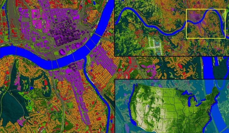
Land Info is a pioneer in the development of object-based image analysis (OBIA) and artificial intelligence (AI) technologies to create value-added map data layers that solve specific customer needs. Services include generation of Digital Surface Models (DSMs), Digital Terrain Models (DTMs), clutter (land-use/cover), 3D vector models (buildings & trees) and additional specialized layers.
Hexagon & Land Info’s Partnership
After conducting extensive R&D to create pilot map datasets for 5G wireless, Land Info determined that the HxGN Content Program gave superior results over traditional lower-resolution satellite sources, most notably for accuracy and detail. The broad availability of the HxGN Content Program enabled Land Info to dramatically grow its mapping services for 5G wireless and offer its specialized solutions across North America and Europe. Land Info’s rapid growth was recognized on the Inc 5000 and the Denver Fast 50 annual rankings.
Recently, Land Info updated its 10-meter resolution thematic raster GIS data of all 50 US states using the HxGN Content Program’s countrywide DSMs. Its land-use/cover data set is optimized for low-band (broad-area coverage) 5G wireless planning and supports additional applications including utilities, insurance and government.
To learn more about Land Info, please visit landinfo.com.