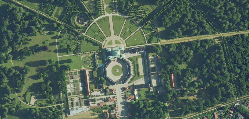
COPENHAGEN, Denmark, (15 November, 2022) — Hexagon’s Geosystems division announced today the HxGN Content Program, the largest library of high-precision airborne data in Europe and the US has updated its high-resolution summer orthophoto database for Denmark, Danmarks Digitale Orthophoto (DDO2022), and made it available via WMS/WMTS.
The summer orthophoto was captured after foliage so that users can see trees, bushes and grass in bright green colours and the crops in growth. Due to the clear visibility of vegetation in rural and urban areas and the availability of the data as traditional RGB and/or colour infrared version (CIR), Hexagon’s DDO program is ideal for analysis and illustration. DDO utilises the most advanced airborne mapping sensors and data processing technologies in the market, to create a seamless 12.5-centimetre resolution orthophoto mosaic based on 15-cm Ground Sample Distance (GSD) data of all of Denmark.
“The DDO program, a well-known Danish brand, has been providing high-resolution orthophotos to the Danish and European market since 1995 and this version of DDO is no. 14 in the series,” says Steen Davidsen, Business Development Director, Geospatial Content Solutions, Hexagon’s Geosystems division. “The 2022 data is part of the HxGN Content Program, which also provides a seamless orthophoto across Europe, allowing our customers to access a pan-European data set reaching outside the borders of Denmark.”
New subscription model in 2022 improves flexibility
The 2022 images will be available on a subscription-based WMS/WMTS service and through Hexagon’s Multi Viewer browser. Users can view the data and integrate it into a broad range of GIS applications, mobile phones and web applications, for use in planning, transport, environmental, telecommunication and energy distribution applications. The subscription model has been updated in 2022, so that Hexagon can offer 1-, 2-, 3- and 4-year subscription agreements depending on the customer’s needs.
The data is considered an ideal training data set for machine learning algorithms that depend on steady streams of input to automatically recognise unique attributes. Customers can use artificial intelligence to automatically extract features in the data to provide valuable information about buildings, roads, railways, vegetation, solar panels and many more.
For more information or to order data, please contact [email protected]
Hexagon Hexagon is a global leader in digital reality solutions, combining sensor, software and autonomous technologies. We are putting data to work to boost efficiency, productivity, quality and safety across industrial, manufacturing, infrastructure, public sector, and mobility applications.
Our technologies are shaping production and people-related ecosystems to become increasingly connected and autonomous – ensuring a scalable, sustainable future.
Hexagon (Nasdaq Stockholm: HEXA B) has approximately 23,000 employees in 50 countries and net sales of approximately 4.3bn EUR. Learn more at hexagon.com and follow us @HexagonAB.
For further information, please contact:
Hexagon’s Geosystems division
Communications Team
[email protected]


